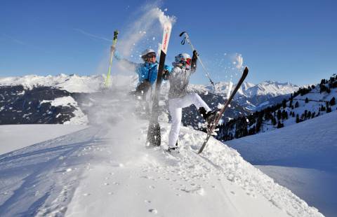
Intermediate hiking routes
Here you will find hiking destinations for hikers with a bit more experience. All of these routes are rated "intermediate". If you don't think of yourself as a beginner anymore, these hikes are most likely perfect for you.
Berlinerhütte
- Total walking time: 4 hours
- Level of difficulty: medium
- Start: Mayrhofen/Gasthaus Breitlahner
- Equipment: good hiking shoes, possibly hiking poles
Description
You can either travel to Mayrhofen by bus or car as far as Gasthaus Breitlahner (there is a parking fee). From there, make your way south, across the stream and via a agricultural road through a patch of forest. Along the way, you will pass the Schwemmalm, a bucolic cafe. Following the road, you will hike up through a series of hairpin bends to the Grawandhütte. Just before the hut, a trail leads up to the Grawand Alm, though you can also continue along the road itself. Now alongside Zemmschlucht canyon, the path will bring you to the restaurant Alpenrose. The agricultural road ends here, with the trail taking you past the war memorial to the Berliner Hütte.
Pfitscherjochhaus
- Total walking time: 4 hours
- Level of difficulty: medium
- Start: Schlegeis reservoir
- Equipment: good hiking shoes, possibly hiking poles
Description
In order to drive to the start of the tour there is a toll charge of 11 Euro per car for use of the tunnel. During this leisurely hike into an area known as the Zamsgrund, with just one easy climb along the way, you will have great views of the gigantic wall of the dam as well as our beautiful reservoir. The hike up to the Pfitscherjoch is a moderately steep climb. You can enjoy a refreshment stop at the Lavitzalm hut, while the return hike follows the same route. During the hike, you will be able to enjoy imposing landscapes of alpine pastures, along with thunderous streams and waterfalls. The Pfitscherjoch offers numerous rest opportunities and is also ideally suited for family hikes!
Maxhütte
- Total walking time: 3 hours
- Level of difficulty: medium
- Start: Ginzling
- Equipment: good hiking shoes, possibly hiking poles
Description
This tour begins immediately by zigzagging up a hiking path. Only when the forest lightens does the climb gradually level off, at which point you continue on with a more leisurely hike. Finally, you are accompanied by the lively waters of the Sturzbach until, towards the end, you cross a bridge to the rustic Maxhütte, which is run by two local farmers.
Schlagalm Hochfügen
- Total walking time: 5 hours
- Level of difficulty: medium
- Start: Uderns or Hochfügen
- Equipment: good hiking shoes, possibly hiking poles
Description
Make your way straight past the parish church to the Kleinboden section of town. After crossing Finsingbach stream, head uphill to the left - a short part along the road - then take the turn-off to the left leading to the Kupfnerberg. Continue past Oberhaus and Seehüter cafes until you reach the Krapfenboden. From there, a gravel path takes you through the forest to the Schlagalm – continue to the Winkelalm – and via the Kegelalm to Hochfügen. You can also take this hike from Hochfügen to Uderns, since a bus runs in both directions
Stillup-Kasseler Hütte
- Total walking time: 4,5 hours
- Level of difficulty: medium
- Start: Gasthaus Wasserfall Stillup
- Equipment: good hiking shoes, possibly hiking poles
Description
The start of this hike is at Gasthaus Wasserfall in Stillup. You can drive your car to this point via a toll road. Now walk alongside the reservoir into the valley. You will come to a long straight stretch, where you will already be able to see your next refreshment opportunity, the Stilluphaus. From there, you continue into the valley, passing by the Taxach Alpe. At the fork in the road, follow the right-hand dirt road - where your climb now begins! You will hike through a patch of forest and come to a supply lift. To the right of the hut by the lift, there begins another climb through woodlands which slowly transitions into shrubs and bushes. After a bridge, you continue to follow the path which now takes you down a series of switchbacks. You will be able to make out a trail approaching from the left, which had originally branched off from the "7-Schneiden-Steig". You, however, will continue to the right and, as you cross the open mountainside, you will be able to enjoy impressive views of the trail you have just walked up below you. Just a few more turns and - all of a sudden - the Kasseler Hütte will be right there before your eyes!
Four-hut-hike
- Total walking time: 3 hours
- Level of difficulty: medium
- Start: Hochfügen parking lot
- Equipment: good hiking shoes, possibly hiking shoes
Description
From the lift car park, hike along a broad, gravel lane into the direction of the Holzalm. From there a hiking path takes you across several small streams with practically no climb in your way. Walk up to the Viertelalm, then gently downhill across the Finsingbach and towards the mouth of the valley and the Pfundsalm. From the Pfundsalm, the path gently leads uphill across the Pfaffenbühel ski slope and through wooded terrain to the Lamarkalm - from there, your trail takes you down the mountain to Hochfügen. This tour can also be hiked in the opposite direction.